![]()
![]()
![]()
![]()
![]()
![]()
![]()
![]()
![]()
![]()
![]()
![]()
![]()
![]()
![]()
![]()
![]()
![]()
![]()
![]()
![]()
![]()
![]()
![]()
![]()
![]()
![]()
![]()
![]()
![]()
![]()
![]()
![]()
![]()
![]()
![]()
![]()
![]()
![]()
![]()
![]()
![]()
![]()
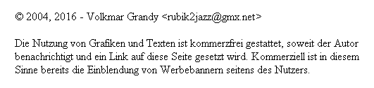
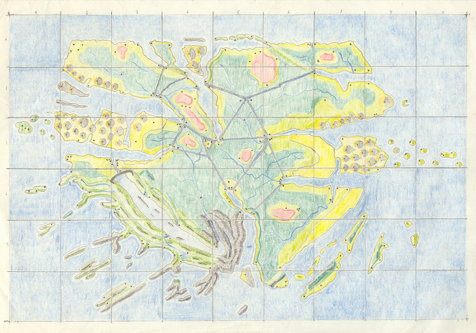
Who is reminded to the Falkland-Islands, isn't wrong. With fourteen, fifteen years I was an interested paper-reader and news-watcher. So I was quite sure influenced by the shape of those troubled islands. But I've to confess, those islands of mine are inhabited by peaceful aliens, who travell across the galaxy and caring for love and peace. Their cities, here shown by spots, are parallel to this function the space-ships themselves. The brown hills are exploited because they consist of a high energy material, more energy-density than uranium or plutonium. This is the fuel of the spaceship-cities. Don't ask me why the continent Barvet needs canals to transport the "cities" allover the country. Perhaps the idea for the channels were influenced by those on mars, which never existed but in the fantasy of the newspapers. The islands in the north were created by the thaught of a visit of my sister to the East Frisian Islands. Vulcanos were inspired by Hawaii, but in this map the vulcanos of the islands are either inactive or afforested. And areas with vulcans are restricted, a kind of natural preserve. Even if there are cities within. The origin of the islands of the southwest is Norway. The flooded valleys must have been an ecological idea to produce clean energy by the citizen ;-) The islands in the southeast are thaughts of the malay archipel. Most canals are crossed by rivers, in a way like some channels are crossing rivers on a bridge. The triangle in the middle is clearly the seat of the government, signed by the red spot. This map was copied by me to the double size, afterwards to a map with a diagonal about 3 meters. All with crayon, pencil, calculator, dividers, set square, ruler. My wish to become a tracer wasn't fulfilled, and not the one to become cartographer :-( But this large map missed the color blue - I was too lazy to draw thos large, boring plains with only a crayon. So I cutted this paper away and overwent this heavy duty ;-) There is a funny story about measuring the land's surface. I thaught about using millimeter paper, and began to confer the contour - but had a better idea. Using poppy seed covering the whole paper, the idea was to suck it with a very special "vacuum cleaner": a glass closed by tinfoil. There were two straws in, one short, this was the one I pulled the air out of the glass, and a long one, bringing in the seed. This to clear the areas which were blue - the unneeded sea districts. And then measuring the volume of the seed covering the land regions. This would have lead to a reckonable volume and then to an approximate number of the paper covered by the seed. My caring mother thaught I was taking drugs - an unidentifiable tool with alloy and pipes, and the moon seed, well known as a base of opium and heroin - but only the callow form of it. I could appease her, but the lust to measure the surface of the land was gone. By the way, the whole planet is covered by water, water and only water. This avoided annoying conflicts with the neighbours ;-) | Wer sich an die Falklandinseln erinnert fühlt, liegt da nicht falsch. Mit vierzehn, fünfzehn Jahren war ich ein interessierter Leser der Tageszeitung und sah auch immer die Abendnachrichten im Fernsehen. Auf diese Art war ich sicher von der Form dieser problembehafteten Inseln beeinflußt. Doch muß ich eingestehen, daß die Bewohner dieser Inseln von friedlichen Außerirdischen bewohnt werden, die durch die Galaxie reisen und sich um Liebe und Frieden kümmern. Ihre Städte, hier als schwarze Punkte angedeutet, waren überdies auch ihre Raumschiffe. Die braunen Berge werden ausgebeutet, da sie aus einem hochenergetischen Material bestehen, mit einer höheren Energiedichte als Uran oder Plutonium. Zugleich ist dies auch der Treibstoff der Raumschiff-Städte. Fragt mich nicht, warum Barvet Kanäle benötigt, um die "Städte" quer über das Land zu transportieren. Vielleicht entstand diese Idee aus den Kanälen auf dem Mars, die ohne Zweifel damals nur in der Fantasie einiger Zeitungen existierten. Die Inseln im Norden entstanden dadurch, daß meine Schwester einmal auf den Ostfriesischen Inseln zur Kur war. Vulkane wurden durch Hawaii inspiriert, doch in dieser Karte sind die Vulkane der Inseln entweder inaktiv oder bewaldet. Und Bereiche mit Vulkanen sind Sonderzonen, eine Art Naturpark. Auch wenn Städte innerhalb dieser Parks liegen. Der Ursprung der Inseln im Südwesten liegt in Norwegen. Die gefluteten Täler müssen eine ökologische Idee der Bürger zur Energiegewinnung gewesen sein ;-) Die Inseln im Südosten sind Gedanken an den malaiischen Archipel. Die meisten Kanäle werden von Flüssen gekreuzt, ähnlich wie bei uns Kanäle Flüsse überqueren. Das Dreieck in der Mitte ist ganz klar der Regierungssitz, der durch einen roten Punkt gekennzeichnet ist. Die Karte wurde von mir zur doppelten Größe übertragen, später dann zu einer noch grösseren Karte mit einem Durchmesser von über 3 Metern. Mein Wunsch, technischer Zeichner zu werden, wurde nicht erfüllt, und auch nicht der zum Kartographen :-( Doch dieser Karte fehlte die Farbe blau - ich war einfach zu faul, diese großen, langweiligen Flächen nur mit einem Buntstift auszumalen. Also schnitt ich dieses Papier einfach ab und überging diese lästige Pflicht ;-) | |||||||||
| Karol van Grymd | Karol van Grymd | |||||||||